Context
This second phase of the project ECOMORE have to take into account new strong concerns at international and regional level especially raised at the COP21 that establish a road map for the thinking and action to be taken to limit the effects of climate change. An action plan to limit global warming and therefore the effects on climate events will have impact only in the long run. However, today, extreme weather events are already becoming more frequent and violent; particularly the heavy rains and floods, become increasingly common in Asia.

In this new context, the most significant risks are then represented by waterborne diseases and vector-borne diseases: contamination of waters that are submerged by water contaminated by human and animal, wildlife encroachment wild on human which increases the risk of zoonotic diseases, environmental pathogens spread by runoff water, role of stagnant water after the water recedes for mosquito breeding… Now there is a cascade of interactions as urbanization, deforestation and agricultural intensification, resulting from economic development, may amplify the impact of climate deregulations.
Public Health concern
A project on re-emergence of neglected diseases. It aims to identify the risk of emergence or re-emergence of diseases in areas with rapid urbanization, ecosystems greatly modified especially during extreme weather events. During flooding, contamination of populations can occur by ingesting contaminated drinking water but also by contact with water; of course the water-borne diseases will be targeted as well as diseases whose development cycle is favored by the trickling, residual standing water or sometimes indirectly, when a vector or vertebrate amplifier operates in the transmission cycle. The project will pay special attention to the fact that while some diseases are studied, others are rather considered neglected diseases or even if they have a control plan, it is not necessarily suited to extreme weather circumstance. The study will take into account the fact that some of these diseases are acute and immediately subsequent to the climatic event and others are deferred because they require a vector or a development cycle. All these parameters should be considered in order to recommend reasoned action plans in short and medium term.
Relevance of the project
It is proposed to implement a climate service which aims to map the risk of dengue and leptospirosis transmission in the targeted countries, which experienced several dengue and leptospirosis outbreaks within the last decade and also to estimate the evolution of those risks under climate change from the IPCC (Intergovernmental Panel on Climate Change) climate multi-model database for different emission scenarios in order to determine if dengue, leptospirosis and vectors can spread outside their current boundaries.
The approach is based on technologies developed for landscape epidemiology, it seems appropriate to adapt this technology into operative studies allowing health authorities to develop viable alternative strategies for controlling vectors, to monitor and anticipate vector-borne diseases and water borne diseases spread and to raise awareness in the population, enabling surveillance, saving time and saving costs.
Primary objective
The study is connected to one sub-goal of the third Global Goals for Sustainable Development web services to monitor diseases related to health and well-being: “Strengthen the capacity of partner countries for early warning, risk reduction and management of national and global health risks”.
Secondary objectives
-
Identification of key climate and environmental factors for vector-borne and water-borne diseases dynamic (outbreaks /emergence) and spatio-temporal variability of vectors
-
Modelling of leptospirosis, dengue and vector risk based on climate and environmental factors
-
Analysis of climate change scenarios and future evolution of key climate factors for disease dynamics
-
Analysis of scenarios of climate change impacts on disease dynamics and attenuation / adaptation potential
-
Decision Support Tool for leptospirosis and dengue risk management

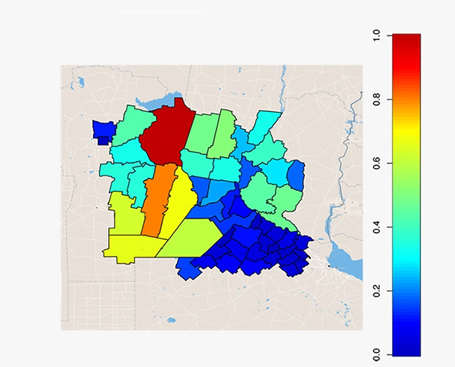
Risk Maps
By means of empirical and satellite data and a history of events it is possible to map the level of risk of a certain zone based on the geographic area. The resulting maps are drawn for specific weather events.
