An innovative program for the control of vectors borne diseases to reduce the risk of dengue, Chikungunya and Zika in urban and peri-urban areas
Context
WHO emphasizes essential points about dengue in its Memorandum No. 117 updated in August 2016; main points are:
- Global incidence of dengue has grown dramatically in recent decades.
- Now, about half the world’s population is at risk.
- Dengue is found in tropical and subtropical regions around the world, with a preference for urban and semi-urban areas.
- Severe dengue is a major cause of serious illness and death among children in Asia.
- There is no specific treatment for dengue and severe dengue, but early detection and access to adequate medical care possible to reduce the mortality rate below 1%.
- The prevention and control of dengue is based on effective measures for vector
A public health concern
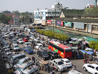
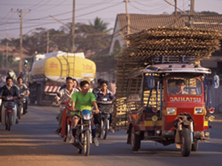
Laos is facing a very fast economic development that generates a significant urban development, particularly in the capital, Vientiane. The urban population increased from 16.85% in 1994 to 37.55% in 2014 according to statistics from the World Bank, and the urbanization rate observed in Laos is one of the highest in the ASEAN countries. The development of peri-urban areas, where high population density is combined with traditional rural activities, offers ideal ecosystem for the proliferation of Aedes, vectors of dengue virus, chikungunya and zika. Movement of populations from rural to urban areas observed in recent years and the increasing number of immigrants are factors that facilitate the circulation of dengue virus between the Laotian provinces but also between the countries of the sub-region.
Relevance of the project
The vector borne diseases surveillance system coordinated by the Institut Pasteur in Laos in Vientiane city and its outskirts at the request of the Lao Ministry of Health (Decree No. 062 / MOH Ministry of Health of Lao PDR; Article 2), has shown active dengue transmission even during the dry season [Lao, 2014] . Infection by one of the four serotypes of dengue virus does not confer protective immunity against other serotypes. The work of numerous teams and the observations of the Institut Pasteur in Laos show that knowledge of the chronology of circulating virus serotypes and their incidence during the dry season may be of a predictive interest on the impact of the disease during the rainy season [Lao, 2014; Lourenço, 2010].
It is also demonstrated that the identification of the most likely sites of contamination can be improved by analyzing the dynamic mapping data of confirmed outbreaks, combined with the study of genomic similarity of viruses and a study of population movements. The goal here is to provide a dynamic mapping model to confirm or reverse that contamination occurs outside or within the community and, in this configuration, to identify “hotspots” of potential contamination to allow better targeting the vector control strategy [Campbell, 2013].
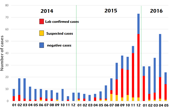 – Epidemic diagram of dengue in 2014 – 2016.
Monitoring data show that the transmission of dengue continues during the dry season from October to March usually (data IP Laos)

Dengue cannot be eliminated, and so the vector control is the only effective means for controlling the disease, pending the evaluation of a vaccine strategy at the regional level [Erlanger, 2008]. Thus, the use of new strategies of vector control during the dry season, based on the use of an innovative technique such as self-release method with trap-boxes In2Care®, must be validated in urban and peri- urban (Figure 3) [Caputo, 2012].
Objective
The general objective of the Lao component of ECOMORE II project is to develop tools for risk assessment, and control of viral diseases transmitted by Aedes species (i.e. dengue / chikungunya / zika) in urban areas to underpin recommendations to minimize public health impacts due to urban development and changes in lifestyle.
Specific objectives
- To determine the prevalence of dengue in the targeted population
- To strengthen monitoring of dengue by integrating geo-location of confirmed cases, to issue dynamic mapping model which includes environmental, climatic, entomologic and socio-economic data
- To improve the differential diagnosis of dengue-like syndromes and so to determine the importance of other diseases transmitted by Aedes or other vectors
- To determine the impact of climatic and environmental conditions on arbovirus transmission by integration of weather and environmental parameters in the analysis of surveillance data
- To describe the dynamic of vectors and improve vector control strategy in urban areas
- To model data to result in identifying major risks and improve outbreak early warning
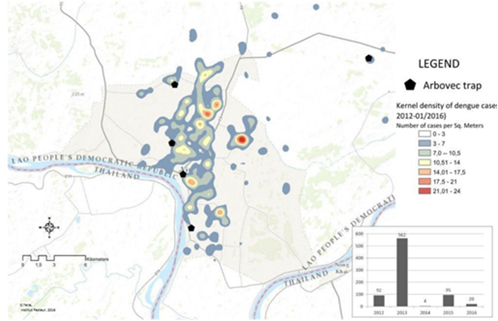
Map showing the distribution and the density of confirmed cases of dengue in the city of Vientiane from 2012 to 2016.